Introduction to Santa Fe
New Mexico - Part 1
 |
 |
| General
view of Santa Fe with background mountains |
The
Governors' Palace in the downtown Plaza |
 |
 |
| An
ancient adobe dwelling in Santa Fe. In the cab
going to the Museum Hill and to the wonderful Museum of
Indian Arts & Culture, I passed by a large number of
these on the Old
Santa Fe Trail heading south-east out of town. |
A door with artful carvings that no yankee artist had produced or corrupted |
Our first hike in the desert around Santa Fe

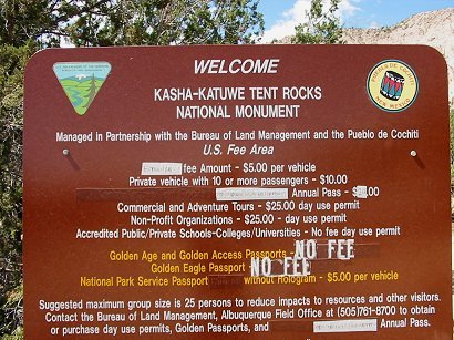
KASHA-KATUWE TENT ROCKS NATIONAL MONUMENT
40 miles south-west of Santa Fe
NLCS Coalition (National Landscape
Conservation System)
Kasha-Katuwe Tent Rocks National Monument
"Cone-shaped rock formations form one of New Mexico's most unusual vistas, and the Monument's archeological sites reflect 4,000 years of human occupation.
Six to seven million years ago, volcanic eruptions spewed rock and ash-sometimes 400 feet thick-for hundreds of miles across the Pajarito Plateau. Wind and water wore into these deposits, creating canyons and arroyos that are today part of the Kasha-Katuwe Tent Rocks National Monument." - NLCS Coalition
________________________________________
"The Jemez Mountains are one of the largest volcanic fields in the world, where volcanoes began rising 13 million years ago, forming the pyroclastic tuffs of Bandelier National Monument and the unusual formations of Kasha-Katuwe Tent Rocks. Valles Caldera is at the heart of a huge volcano that once reached perhaps 30,000ft; you could see it from Texas, where pieces of it are still found. These volcanoes are dormant, not dead."
"Kasha-Katuwe Tent Rocks National Monument: "The real treat is Canyon Trail, an easy and spectacular 2-mile roundtrip, threading a narrow 30ft-tall canyon with walls so close together that you can touch both sides. The steep final leg climbs to a perfect vista overlooking the odd landscape." (Santa Fe and Taos - Lonely planet)
 |
 |
| John is
setting out on the Canyon Trail to the top of the Tent Rocks hill, a
"spectacular 2-mile roundtrip". |
On our
way to the base of the desert-like path up to the top of the cliff,
starting with the narrow canyon. |
 |
French friend Philippe et moi on our way to the narrow 30ft-tall canyon with walls so close you can touch both sides. The tent formations are behind and above us. |
Close-up of the volcanic rock at this site - "this bizarre and beautiful geological formation of tent-shaped hoodoos". (Santa Fe and Taos - Lonely planet) |
 |
 |
 |
| Further
on in the narrow canyon |
Philppe
et moi once again |
 |
 |
| Close-up
of tent formations |
Millions
of years of erosion |
 |
Siv lost in the midst of these extraordinary wonders of the world
|
Philippe,
l'alpiniste, showing off in the narrow canyon
|
 |
 |
A side view of the cliff we are going to climb |
 |
We are setting out on the climb up to the top of the cliff |
Beautiful desert flowers on the way up the hill, possibly bitterweed. They also look like a yellow variation of Indian paintbrush - if such a flower exists. |
 |
 |
Philippe with the top of the hill behind him, still on our way up. |
View west over the wing of the cliff, the very top of the cliff on the left here. |
 |
 |
View out over the snow-capped mountains far away |
 |
Orange flowers, probably Indian paintbrush. Not sure. |
 |
Another view from the top. A mesa to the left and the snow-capped sierras on the right in the background. |
 |
1 |
| Fantastic view of the famous tents |
Leaving
the top of the cliff behind us now. |
 |
 |
| We are
getting close to the narrow pass on our way back, leaving the 'tents'
behind us. |
Getting
back to the narrow place in the canyon |
 |
 |
| Erosion
in the side of the volcanic rock |
A
buzzard (?) flying low over the rocks as we are back to our starting
point. |
Go
to New Mexico - Part 2