Siv & John in northern Lapland - July 2002
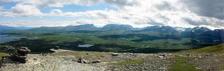
View of Lapporten and the mountains towards the south from
Nuolja
For more pictures from Abisko - Part 1, click here
For map of northern Lapland, click here
For map of Abisko and surroundings, click here
We arrived at Kiruna Airport on July 18
around noon, having planned on taking the bus to the train station 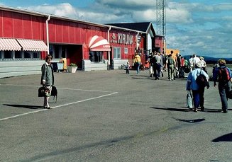 and the train from there to Abisko.
To our profound relief and joy, when we got out in front of the
airport, we found a bus waiting for airplane passengers to take us
direct to Abisko. Wonderful surprise! After a couple of hours' ride
through beautiful countryside, the bus left us off right in front of
the tourist station. The walk up a slightly hilly path was lined with
masses of glorious mjölke (willow herb), which we were to
see in varying shades of red
on road sides and forest borders all over this
and the train from there to Abisko.
To our profound relief and joy, when we got out in front of the
airport, we found a bus waiting for airplane passengers to take us
direct to Abisko. Wonderful surprise! After a couple of hours' ride
through beautiful countryside, the bus left us off right in front of
the tourist station. The walk up a slightly hilly path was lined with
masses of glorious mjölke (willow herb), which we were to
see in varying shades of red
on road sides and forest borders all over this 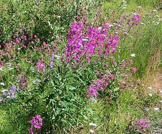 part of the world.
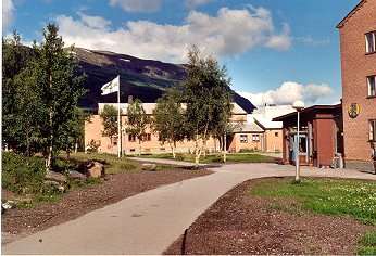
Abisko tourist station had changed somewhat since I and my family were there about 50 years ago. The old buildings burned down in 1949 and were replaced by accommodations admittedly less charming but more convenient for the great influx of tourists they now receive yearly, during all seasons, and from all countries.
The first tourist station in Abisko was a house left over from the 'rallare' - railroad workers - who had been working for years building the railroad that was to ship iron ore from Kirunavaara - Luossavaara iron mines to the harbor in Narvik which is free of ice all year round, due to the Gulf stream. The first tourist station dated from 1910 and when it was taken over by STF (Svenska Turistföreningen - the Swedish Touring Club) from the state-owned railroad company, it was declared clean and fit for use. However, it took a whole lot of time and work to clean it out to even make it possible for the first courageous tourists to come and spend the night in this primitive house. Over the years, additions were made, which made it a most comfortable tourist hotel in the traditional Swedish wooden manor-house style. Added to the main building were quite a few small cabins, where you had the choice of doing your own cooking or having your meals at the hotel. The rebuilding and extensions of Abisko tourist hotel were finished in 1943.
You may imagine that you remember everything from when you were a
young kid in the late 40's, but that is one impression that would prove
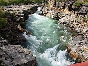
to be utterly false. I had completely forgotten the wild beauty of
Abiskojokk canyon and it was a wonderful surprise on that first
afternoon when we suddenly came upon the churning waters in the canyon,
dug into the rock
over thousands and thousands of years.
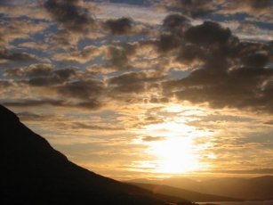
 The view from the dining
room over Torneträsk, the huge lake north of the mountain station,
is breathtaking. At the height of the summertime
(end June, beginning July), you see the sun set behind the mountains on
the northern side of the lake just before midnight. But you can also
take
the chair lift up on the mountain Nuolja (alt. spelling - Njulla) and
see
the unforgettable midnight sun, if you get to Abisko early enough in
July.
The view from the dining
room over Torneträsk, the huge lake north of the mountain station,
is breathtaking. At the height of the summertime
(end June, beginning July), you see the sun set behind the mountains on
the northern side of the lake just before midnight. But you can also
take
the chair lift up on the mountain Nuolja (alt. spelling - Njulla) and
see
the unforgettable midnight sun, if you get to Abisko early enough in
July.
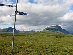
Abisko, 250 km north of the Arctic circle has been a popular tourist destination for a hundred years. It is the northernmost point of Kungsleden (the King's Trail), the 440 kilometer long trail that goes south through Lapland - to Hemavan in mid Lapland - first passing close to Kebnekajse tourist station, about four days good walking from Abisko, and then on towards Saltoluokta and the lake Stora Lulevatten.
This long lake system is the northern border of Sarek National Park, the uniquely beautiful and wild mountain massif which is one of the very few totally unspoiled mountain areas in this part of the world. Sarek is said to be Europe's last wilderness area. There are mountains, with peaks around 2000 meters, glaciers, and valleys, but you have to carry your house and provisions on your back. The valleys Rapadalen in the heart of Sarek, going east towards Aktse on Kungsleden and Tarradalen (the south-eastern border of Sarek) both have micro climates that make them seem almost like jungles. Plants reach heights that are triple or quadruple their ordinary heights. If you continue on Kungsleden south towards Kvikkjokk, at Stora Lulevatten and Saltoluokta you will get to the eastern border of the Sarek massif. This is untouched wilderness which there is barely any equivalent to in this part of the world. The path from Abisko to Kvikkjokk is 182 kilometers of wondrously beautiful mountain plateaus, moors and birch forests, overlooking untouched valleys. Less than 100 kilomters south of Abisko the path gets close to Kebnekajse, the highest mountain in Sweden - 2123 m. officially et the time, but the packed snow on the south peak is about 25 meters thick and it keeps steadily melting away.
Sarek is a most impressive national park in Sweden, north of the arctic circle and stretching over 1970 km². It is said to be the most magnificent domain of untouched wilderness in all of Europe, and for centuries it has been used as summer pastureland for reindeer. The Sami people (Saemieh, the reindeer people, for more information, click here) follow the reindeer and they have a well established summer village (sameviste) in Vaisaluokta at the northern boundary of Sarek, north of the big lakes Virihaure and Vastenjaure, with wonderful Staloluokta situated at the south-eastern end of the lakes. These lakes are often said to be the most beautiful lakes in Lapland. Staloluokta is on the Padjelantaleden where cabins were set up by the Swedish Environmental Protection Agency. These cabins are now run by the Samis who make a living off fishing and small tourist business. In Stalo, you can buy freshly smoked trout in the evenings every day in the summer time. There are at least two Sami families who run kiosks where tourists can buy things ranging from thin bread and canned milk to hand-made Sami products. (For some of the information about Sarek, credit is given to Ulf Mjörnmark)
Back in 1950, we never walked into Sarek, but we skirted it pretty much all around and were overwhelmed by the beauty of it, the awesome and untouched wilderness. As a young kid I remember standing at a high spot on the eastern edge of Sarek close to Aktse, overlooking a valley. There were patches of weathered snow around us and, far below, there was the moving water of a stream. I had the distinct feeling that no human being had ever set foot on the very spot where I was standing.
Adding the national parks Padjelanta (1984 km²) and Stora Sjöfallet (1278 km²) to Sarek National Park, this makes up the area that was declared part of the World Heritage Laponia by Unesco in December 1996.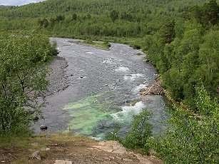
The first day, our short walk (4 - 5 km) went via Marmorbrottet (the Marble quarry), a cliff overlooking the Abiskojokk (jokk or jåkkå - Sami for stream) where a picnic table and benches were set up for the comfort of hikers. This is one of two beginning paths of Kungsleden going south to Abiskojaure (jaure - Sami for lake) and then on towards Kebnekajse. View from Marmorbrottet on the right.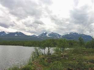
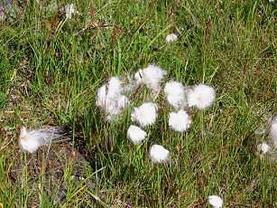
We turned east to make a round trip back to the tourist station and the path took us to a gorgeous lake with a view to the south over snowy mountains and then across a marsh with a mess of cloud berries (Sw. hjortron) and what we (John and I) call cotton flowers.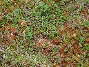 This was July 19 and the cloud
berries were
still a bit sour, even though they looked ripe. However, 2002 was a
cold summer in Lapland and the berries may not have ever become really
sweet this year.
This was July 19 and the cloud
berries were
still a bit sour, even though they looked ripe. However, 2002 was a
cold summer in Lapland and the berries may not have ever become really
sweet this year.
For the protection of the precious wilderness and maybe also for the comfort of the hikers, planks are placed across the soggy moor and we didn't even have to get our feet wet. I remember vividly the days when we were hiking on Kungsleden towards Kebnekajse and there were times when we had to cross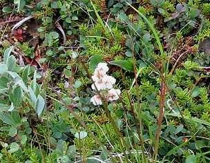 a stream. The only way to get across was to take your
boots off, attach them onto your backpacks and wade across,
taking great care not to fall on the slippery and somewhat moving
stones
in the water. And believe me, the water was cold! Times have changed,
and
today we are told never to ford a stream barefoot. Sound advice no
doubt.
a stream. The only way to get across was to take your
boots off, attach them onto your backpacks and wade across,
taking great care not to fall on the slippery and somewhat moving
stones
in the water. And believe me, the water was cold! Times have changed,
and
today we are told never to ford a stream barefoot. Sound advice no
doubt.
The delightful little flower on the right is a pyrola (vitpyrola? - wintergreen, Wintergrün - family Pyrolaceae).
The next day, we were planning on getting up on Nuolja, but we were not trying to walk all the way up. There is a chair lift that wasn't there in 1950 and we were going to take advantage of modern technology.
and the train from there to Abisko.
To our profound relief and joy, when we got out in front of the
airport, we found a bus waiting for airplane passengers to take us
direct to Abisko. Wonderful surprise! After a couple of hours' ride
through beautiful countryside, the bus left us off right in front of
the tourist station. The walk up a slightly hilly path was lined with
masses of glorious mjölke (willow herb), which we were to
see in varying shades of red
on road sides and forest borders all over this part of the world.Abisko tourist station had changed somewhat since I and my family were there about 50 years ago. The old buildings burned down in 1949 and were replaced by accommodations admittedly less charming but more convenient for the great influx of tourists they now receive yearly, during all seasons, and from all countries.
The first tourist station in Abisko was a house left over from the 'rallare' - railroad workers - who had been working for years building the railroad that was to ship iron ore from Kirunavaara - Luossavaara iron mines to the harbor in Narvik which is free of ice all year round, due to the Gulf stream. The first tourist station dated from 1910 and when it was taken over by STF (Svenska Turistföreningen - the Swedish Touring Club) from the state-owned railroad company, it was declared clean and fit for use. However, it took a whole lot of time and work to clean it out to even make it possible for the first courageous tourists to come and spend the night in this primitive house. Over the years, additions were made, which made it a most comfortable tourist hotel in the traditional Swedish wooden manor-house style. Added to the main building were quite a few small cabins, where you had the choice of doing your own cooking or having your meals at the hotel. The rebuilding and extensions of Abisko tourist hotel were finished in 1943.
One small building remains from before the 1949
fire - the rest are modern brick buildings, fairly straight forward,
but made for the comfort of the masses of tourists of all ages, from
small children to elderly people who, in some cases, even
have a hard time moving around the precincts.
The view from the dining
room over Torneträsk, the huge lake north of the mountain station,
is breathtaking. At the height of the summertime
(end June, beginning July), you see the sun set behind the mountains on
the northern side of the lake just before midnight. But you can also
take
the chair lift up on the mountain Nuolja (alt. spelling - Njulla) and
see
the unforgettable midnight sun, if you get to Abisko early enough in
July. Abisko, 250 km north of the Arctic circle has been a popular tourist destination for a hundred years. It is the northernmost point of Kungsleden (the King's Trail), the 440 kilometer long trail that goes south through Lapland - to Hemavan in mid Lapland - first passing close to Kebnekajse tourist station, about four days good walking from Abisko, and then on towards Saltoluokta and the lake Stora Lulevatten.
This long lake system is the northern border of Sarek National Park, the uniquely beautiful and wild mountain massif which is one of the very few totally unspoiled mountain areas in this part of the world. Sarek is said to be Europe's last wilderness area. There are mountains, with peaks around 2000 meters, glaciers, and valleys, but you have to carry your house and provisions on your back. The valleys Rapadalen in the heart of Sarek, going east towards Aktse on Kungsleden and Tarradalen (the south-eastern border of Sarek) both have micro climates that make them seem almost like jungles. Plants reach heights that are triple or quadruple their ordinary heights. If you continue on Kungsleden south towards Kvikkjokk, at Stora Lulevatten and Saltoluokta you will get to the eastern border of the Sarek massif. This is untouched wilderness which there is barely any equivalent to in this part of the world. The path from Abisko to Kvikkjokk is 182 kilometers of wondrously beautiful mountain plateaus, moors and birch forests, overlooking untouched valleys. Less than 100 kilomters south of Abisko the path gets close to Kebnekajse, the highest mountain in Sweden - 2123 m. officially et the time, but the packed snow on the south peak is about 25 meters thick and it keeps steadily melting away.
Sarek is a most impressive national park in Sweden, north of the arctic circle and stretching over 1970 km². It is said to be the most magnificent domain of untouched wilderness in all of Europe, and for centuries it has been used as summer pastureland for reindeer. The Sami people (Saemieh, the reindeer people, for more information, click here) follow the reindeer and they have a well established summer village (sameviste) in Vaisaluokta at the northern boundary of Sarek, north of the big lakes Virihaure and Vastenjaure, with wonderful Staloluokta situated at the south-eastern end of the lakes. These lakes are often said to be the most beautiful lakes in Lapland. Staloluokta is on the Padjelantaleden where cabins were set up by the Swedish Environmental Protection Agency. These cabins are now run by the Samis who make a living off fishing and small tourist business. In Stalo, you can buy freshly smoked trout in the evenings every day in the summer time. There are at least two Sami families who run kiosks where tourists can buy things ranging from thin bread and canned milk to hand-made Sami products. (For some of the information about Sarek, credit is given to Ulf Mjörnmark)
Back in 1950, we never walked into Sarek, but we skirted it pretty much all around and were overwhelmed by the beauty of it, the awesome and untouched wilderness. As a young kid I remember standing at a high spot on the eastern edge of Sarek close to Aktse, overlooking a valley. There were patches of weathered snow around us and, far below, there was the moving water of a stream. I had the distinct feeling that no human being had ever set foot on the very spot where I was standing.
Adding the national parks Padjelanta (1984 km²) and Stora Sjöfallet (1278 km²) to Sarek National Park, this makes up the area that was declared part of the World Heritage Laponia by Unesco in December 1996.
The first day, our short walk (4 - 5 km) went via Marmorbrottet (the Marble quarry), a cliff overlooking the Abiskojokk (jokk or jåkkå - Sami for stream) where a picnic table and benches were set up for the comfort of hikers. This is one of two beginning paths of Kungsleden going south to Abiskojaure (jaure - Sami for lake) and then on towards Kebnekajse. View from Marmorbrottet on the right.
We turned east to make a round trip back to the tourist station and the path took us to a gorgeous lake with a view to the south over snowy mountains and then across a marsh with a mess of cloud berries (Sw. hjortron) and what we (John and I) call cotton flowers.
This was July 19 and the cloud
berries were
still a bit sour, even though they looked ripe. However, 2002 was a
cold summer in Lapland and the berries may not have ever become really
sweet this year. For the protection of the precious wilderness and maybe also for the comfort of the hikers, planks are placed across the soggy moor and we didn't even have to get our feet wet. I remember vividly the days when we were hiking on Kungsleden towards Kebnekajse and there were times when we had to cross
a stream. The only way to get across was to take your
boots off, attach them onto your backpacks and wade across,
taking great care not to fall on the slippery and somewhat moving
stones
in the water. And believe me, the water was cold! Times have changed,
and
today we are told never to ford a stream barefoot. Sound advice no
doubt. The delightful little flower on the right is a pyrola (vitpyrola? - wintergreen, Wintergrün - family Pyrolaceae).
The next day, we were planning on getting up on Nuolja, but we were not trying to walk all the way up. There is a chair lift that wasn't there in 1950 and we were going to take advantage of modern technology.